|
|
|
| Saxmundham Suffolk, England |
|
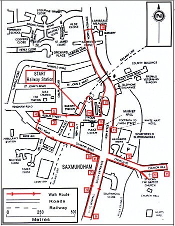
| Fact File: | Location: Saxmundham is 23 miles north east of Ipswich Start: Saxmundham Station - Ordnance Survey map reference TM 385631 Length: 2˝ miles Conditions: Surfaced footway and road, no stiles or gates How to get there: - Travel Information: For general public transport information tel. Suffolk County Council's TraveLine - 08459 583358 or Anglia Rail - 01473 693396 By Road: From Ipswich via A1214 and A12 north, turn off on Saxmundham by-pass Car parking: Pay and display at Market Place and Church Street Refreshments: A wide range of shops, pubs, restaurants and takeaways in the town Public Toilets: Market Place car park Map: Ordnance Survey Explorer sheet 212 Woodbridge and Saxmundham |
 |
| Experience: |
Saxmundham derives its name from the Saxon and Old English Seaxmund's homestead, the earliest record of the name is in the Domesday Survey which mentions three churches. The small market town stands on the River Fromus, a tributary of the River Alde, on the old A12 coaching road from London to Great Yarmouth and on the East Suffolk Railway line from Ipswich to Lowestoft. The town trail starts at the railway station, opened in 1859 and an important point on the East Suffolk Railway for it is from this signal box that that the whole of the line is controlled. Apart from the platforms, the station building is no longer used for railway purposes, but in times past this was the junction for the Leiston and Aldeburgh branch line where holiday makers from London made their way to the coast. The branch line closed for passengers in 1966 and now only serves the power stations at Sizewell. Across the road is the Railway Inn (1) still providing refreshment for travellers; turn right across the tracks into Albion Street and note the railway cottages (2) on the right, with a carriageway arch at the centre. Opposite is the former old red brick Victorian police station (3) that has retained its lock-up, although it is now a private house. Walk to the top of the street to the junction with Rendham Road and the brick base of the windmill (4) that stood here until 1907. The mill was built of wood and was extended above the height of the surrounding buildings, reputedly to have been one of the tallest in Suffolk. Return to Albion Street and take the path at the side of No. 50, the local water pump stood on the right at the bottom of the steps down to Mill Road. Turn left down the road and across the railway to Chantry Road, passing the 18th century timber framed Chantry Cottages (5) on the right and Chantry House (6) on the corner. Turn right along South Entrance noting the 3 storey 19th century house (7) built in yellow Suffolk brick and the 17th century timber framed 3 storey cottages nearby. The Texaco garage stands on the site of the first garage to be built in Saxmundham and once boasted the only petrol pump for miles around. Monks Cottages (8) on the right are some of the town's oldest dwellings and can be identified by the chequered pargetting, simulating the original 17th century style of decoration. The last house on the right was once the home of William Bright the artist and for several years was occupied by the headquarters of Suffolk Wildlife Trust. Cross the road here and note Crown Cottage (9) with its traditional Suffolk bay window, Tudor beam and 16 inch thick front wall. Return to the crossroads and turn right into Church Street, walking over the bridge across the River Fromus and up the tree lined path to the parish Church of St. John the Baptist (10). The church is built on a prominence overlooking the town and is thought to have been built on the site of a Saxon church, it contains portions dating from 1250. Inside is a carved stone font bearing effigies of the Woodwoses, or Wild Men of the Woods, the mystical men of Suffolk, and is surmonted by a wooden font cover bearing a figure of St. John the Baptist. Return to the road and turn right up Church Hill to the thatched cottages (11) on the right. These were built in 1836 as a single storey church school, a second floor library and reading room were added 40 years later. They have since been converted into a row of four cottages. Return down the hill and across the river, the area of car park on the right (12) is the site of the town's old livestock market, granted by charter in 1272 by King Edward I to John de Ramsey, Lord of the Manor, eventually closing in 1987. Continue on to the traffic lights at the cross roads and turn right into the High Street, a conservation area containing many Tudor buildings with Victorian facades. Particularly note the 17th century White Hart Inn (13) sporting 19th century chimney stacks and the Market Hall (14), built as a Corn Exchange in 1846 and given to the town by the Long family who have their coat of arms above the door. The Bell Inn (15) was rebuilt in 1842 on the site of a former inn and was a regular stop for the mail and stage coaches that regularly ran the route from London to Yarmouth. Walk on past the crinkle crankle wall on the left, then the town sign at the junction with Street Farm Road and on under the railway bridge along North Entrance. There are a number of fine houses to be seen here as you walk on as far as Lambsale Meadow (16) and the new surgery complex that stands on the site of the former Lamb Sale and Hirings Fair that was once held here by the riverside. Return back to the town under the railway bridge and turn right into the Market Place, an area of two parallel streets and the venue of the town's street markets for centuries. On the left are a number of cottages that have been converted from the old 16th century Angel Inn (17) that once faced the High Street and contained cobbled yard, stables and pumped horse trough to serve the needs of travellers arriving along the A12. At the end of the street turn right into Station Approach and right again past the front of Old Bank House (18), Saxmundham's first bank built by Gurneys in the 18th century. Walk on to reach the entrance to the car park, walking up through the car park to a set of steps at the top leading to the railway. Turn left along the station platform to complete your walk. |
|
| |
||
| |
||
|
|